

The aim is to preserve geological heritage and raise public awareness through tourism. It is not easy to be identified as a “Pro-Geopark” site. The chosen site should ideally include elements of ecology, archaeology, geology, history, and culture, as well as ensuring that the relationship between these elements is always preserved through sustainable and comprehensive management and maintenance. It is a remarkable effort when we consider how intense it is when compared to other countries and the criteria required to be qualified as a UNESCO heritage. If you find this article interesting and want to experience it for yourself, don’t forget to include the 10 Geopark Sites that listed here!
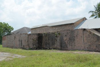
Batu Arang. Photo; Majlis Pembandaran Selayang
Former Coal Mine, Batu Arang
This former coal mine is a living lake with Geopark potential because it once stored the largest pile of coal in Peninsular Malaysia and is the second-largest former opencast mine in Peninsular Malaysia. For now, the former mine area is still abandoned while the surrounding area, which consists of local community housing, is also used as a hamlet or small garden.
This former mining area also holds outcrops of Belata Formation rocks which are the base of the basin and shale rocks which are also part of the basin sediments forming the Coal Layer.
This Geopark is important from the anthropogenic aspect and is the result of the Batu Arang basin episode.
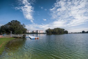
Seri Kundang Blue Lake
Seri Kundang Blue Lake
Tasik Biru in Seri Kundang is a former tin mine in Rawang that has been filled with water. Although this lake is only economically significant in the Gombak district, it is also an open-pit mining area that serves as a recreation and settlement centre.
The Tasik Biru area is easy to find and has several alternative access points, including a nearby playground.
Tasik Biru, a former ore mine area, is a contact zone between igneous rocks and background rocks that produced tin minerals during the tectonic process that occurred in this area. There are piles of Quaternary sediments consisting of sand and round pebbles of various sizes visible on the cliff, particularly near the playground and the row of shops.
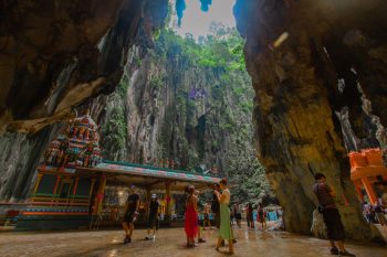
Holocene Fossils, Batu Caves
Holocene Fossils, Batu Caves
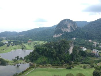
Batu Caves is a limestone hill which is a remnant of the limestone surface from Kuala Lumpur. This limestone was formed in the final stage of shallow marine sedimentation during the Lower Silurian period.
The formation of caves around these hills occurred throughout the Basin filling episode from the Paleocene to the Holocene which involved changes in the groundwater level and dissolution of the limestone that formed the caves. The presence of this limestone cave encourages habitat space for habitat throughout the ice age which also affects the natural structure of this area. Among the Holocene fossils found around this area include orangutans and tigers and more than 60 other types of species from 20 caves around this hill.
As a geosite, this hill is important as an area that recorded various fossils and species around this basin during the Holocene. Batu Caves is a limestone hill that is a remnant of Kuala Lumpur’s limestone surface. During the Lower Silurian period, this limestone was formed in the final stage of shallow marine sedimentation.
The formation of caves around these hills occurred throughout the Paleocene to Holocene Basin filling episode, which involved changes in groundwater level and dissolution of the limestone that formed the caves. The presence of this limestone cave promotes habitat space for habitat throughout the ice age, influencing the natural structure of this area. Orangutans, tigers, and more than 60 other types of species have been discovered in 20 caves around this hill as Holocene fossils.
This hill is a significant geosite because it recorded various fossils and life around this basin during the Holocene.
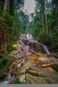
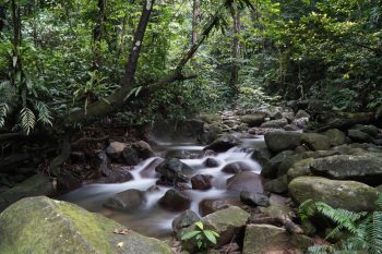
Kanching River Waterfall
Kanching River Waterfall
This geosite is located in the Kanching Recreation Area between HS Kanching and HS Lagong. The Dipterocarp Forest of Pamah and Bukit Hutan is a rich mixture of various species of unique flora and fauna. There are built tracks to explore and they are easy to navigate. Arriving there, you will definitely see the commotion from the activities of visitors who mostly visit the area for leisure due to the various facilities provided.
This makes the area a very suitable site for recreational and public education purposes. As a potential Geopark, this waterfall is formed along the Northeast-Southwest axis. As a result of the process of erosion and displacement; the foundation is more intensive than other places because it is located in the same direction or parallel which indirectly produces 7 levels of waterfalls which are the attraction of this area. The area is linked to the city centre or the main route through the Kuala Lumpur-Endau Fault.
Kuala Lumpur Bukit Takun Limestone
As can be seen in the Batu Caves area, the limestone near Bukit Anak Takun and Bukit Takun was formed as a result of the robust and intact rock formations that did not move away from their original place. This location represents the final deposit of sediments from the deposition process on the shallow sea platform before changes occurred as a result of ocean closures, making it a prospective geosite.
Kuala Lumpur Bukit Takun Limestone
Limestone fossils, such as those of the corals Ketaphyllumaff, Turbinatum, Heliolitessp, and Halysitessp, can be found in abundance in these rocks, especially in the horizon or below the series. The finding of this brachiopod fossil has led to the proposed age of the Kuala Lumpur limestone to the Middle-Late Silurian (Ludlow) period.
Sedimentation at a shallow sea that fed into or fed into the enormous ocean during the Silurian period is credited with creating the bentonite fossil that was discovered. There have been reports of similar fossil species being discovered in Europe and Burma.
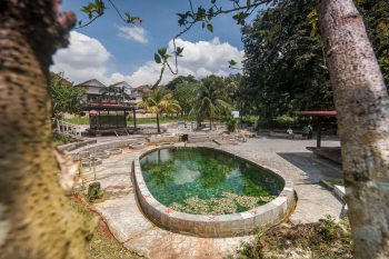
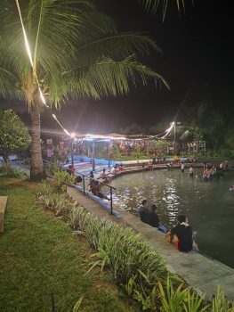
Selayang Hot Spring
Selayang Hot Spring
Selayang hot spring is a natural hot spring, resulting from the flow of water to the surface after going through the heating level along the intensive fault at 120 degrees. These intensive faults are associated with the presence of major faults formed as a result of the process of erosion, displacement and the formation of the Jura-limestone basin. Its importance as a Geosite is closely related to the intensive fault known as the Kuala Lumpur-Endau Fault. This hot spring has a temperature of around 46 degrees Celsius and has become a recreation centre for the local community. There are many facilities that have been developed in this area that led to the use of hot springs for a short time.
Sungai Lalang Hot Spring
Sungai Lalang Hot Spring
Sungai Lalang hot spring is a natural hot spring resulted from the heating of surface water along the cracks formed during the process of erosion, displacement and formation of the Jura-Cretaceous period basin. The main fault is in the northwest-southeast direction as part of the Kuala Lumpur fault zone which is also cut by a series of vertical faults in the northeast-southwest direction. There are two main sources of hot springs found in this area with the highest recorded temperature at 51 degrees Celsius. Currently, hot spring locations that are open to the public are available with basic facilities of bathrooms, toilets and rest areas maintained by private owners.
Tekala River Waterfall
Tekala River Waterfall
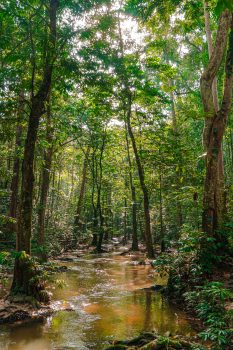
This geosite is located in the Sungai Tekala Recreational Forest area, in the Sungai Lalang Forest Reserve which is a lowland dipterocarp forest. Sungai Tekala waterfall was formed by a series of linea menia in the form of faults in the North-West-South-East direction. Or known as the Kuala Lumpur Fault which causes a uniform fall. Faults were formed during the process of erosion, displacement and basin formation during the Jura-Cretaceous that produced a total of 4 levels of waterfalls. This waterfall is easy to access with facilities for tourists available, but it is better known as a picnic site based on its original construction purposes by the Selangor State Forestry Department. The integration of rocks and biological diversity found in this area is very suitable for recreational and public education purposes.
Gunung Nuang Granite Peak
This geosite is located in the Gunung Nuang Recreational Forest area located within the Hulu Langat Forest Reserve area. This forest area is a mixed Dipterocarp hill forest. The mountain was formed by microgranite rocks that were a follow-up strike during the granite rift episode in the Late Triassic. True to the name, the first encounter of microgranite in Genting Sempah. However, the Gunung Nuang area recorded well-preserved microgranite outcrops along the river, especially in the area near the top of the mountain. Access to the geosite area is easy by using forest paths or trails along with basic level tourism facilities more suitable for hikers. The presence of rocks and the link with biology in this area, it is very suitable for recreational and public education purposes.
Gunung Nuang Granite Peak
Selangor Gombak Quartz Ridge
The quartz ridge found in this area is a ridge formed along the main fault, known as the Kuala Lumpur-Endau Fault. The history of the formation of this ridge is consistent with the episode of ridges produced by hydrothermal dissolution and fault filling in the Late Cretaceous (82 million years ago).
This ridge was originally a crust formed in the earth but was exposed to the surface during an episode of basin filling in the Paleocene-Holocene period through intensive weathering. The hard nature of the quartz mineral compared to the granite rock that turns into soil accentuates the shape of the ridge.
Selangor Gombak Quartz Ridge
The Gombak quartz ridge geosite has not only been proven to be a fill of clod along the main fault, but it is also very important for ecology and recorded the longest quartz ridge in Malaysia and abroad at a distance of 14km. Being in a township makes the site a major community recreation area despite having no recognised trails.